Fjernsupport forbinder sig kun til computeren på jeres anmodning og med jeres samtykke.
CLARYEL SRLS · Fino Mornasco (CO) · P.IVA 04258140138Bando Nuova Impresa 2026 — Regione Lombardia1 års garanti, kan forlænges
Tal. CLARYEL klarer resten.
Spørg højt: din lokale AI finder, analyserer og løser.
100+ sprog · stemme og tekst
Systemet kommunikerer med stemme og tekst på 100+ sprog: på det sprog, du spørger på, svarer det.
Et stemmespørgsmål om dokumenter i ERP-systemet: systemet fandt falske fakturaer og dubletter.
En anmodning om at slette dem: her er resultatet.Det er sikkert at slette dokumenter: data sikkerhedskopieres, der er en ændringshistorik med mulighed for at rulle tilbage og en løbende afstemning, for eksempel med kontoudtog.
Et teknisk spørgsmål: systemet svarede detaljeret.
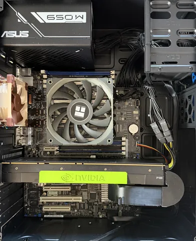
En kraftig computer, som vi gør klar til jeres kontor. Indeni: AI-assistenten, dokumentarkivet med søgning og sikkerhedskopier. I bruger den fra browseren, fra iPhone og fra Android.
1 års garanti for virksomheder, kan forlænges.
Supportplanen
Hver computer leveres med den gratis Basisplan. Med de betalte planer, fra 29,99 € om måneden, tager vores AI-agenter og specialister sig også af den software, I tilføjer, og svarer på bredere spørgsmål.
Hvis en abonnementsbetaling udebliver, stopper tjenesten med det samme. Garantisager håndteres stadig.
Tre niveauer
Tre niveauer af privat lokal AI
Vælg et startniveau; vi forbereder en tilgængelig konfiguration til dine opgaver.
Lokal AI Start
Lokal computer med skrivebordBruges ved arbejdspladsen; på et lille kontor skiftes kolleger. Med jeres tilladelse fjernadgang fra telefonen.
Før opkaldet analyserer vi branchen ud fra et spørgeskema eller en stemmefortælling om virksomheden og sender en AI-præsentation til jeres sag (arkitektur og behov).
Derefter onlinekonsultationen.
Como / Fino Mornasco / nærområdet: stifterbesøg muligt. Meget begrænset, kun ved start.
De 99,00 € trækkes fra CLARYEL Box-hardwaren.
Også uden Box eller vores ydelser får I en detaljeret konsultation om jeres forretning: moderne AI sikkert efter EU- og italiensk ret.
Hvis I efter konsultationen afviser ydelsen, refunderer vi 50% af de 99,00 €.
Tilbagebetalingen på 50% er en kommerciel betingelse i dette tilbud til virksomheder og er en del af vores salgsbetingelser.
Det er en computer til kunstig intelligens, der står på jeres kontor, sammen med en supportplan. Indeni er AI-assistenten, dokumentarkivet med søgning, sikkerhedskopier og sikkerhedsfunktioner. I bruger den fra browseren, fra iPhone eller fra Android.
Sælger I også til privatpersoner?
Nej. I denne fase sælger vi kun til virksomheder og selvstændige med momsnummer.
Forlader mine data kontoret?
AI-modellerne, dokumentarkivet og hukommelsen kører på computeren på jeres kontor. Data kan blive hos jer: intet forlader stedet uden en vej, I selv bestemmer. Skyen er valgfri. Fjernsupport forbinder sig kun til computeren på jeres anmodning og med jeres samtykke.
Hvad sker der, hvis jeg holder op med at betale for planen?
Tjenesten i den betalte plan stopper straks. Garantien på computeren og de tilfælde, den dækker, gælder fortsat.
Hvordan betaler jeg? Får jeg en elektronisk faktura?
Konsultationen til 81,15 € + moms betales online med kort. Box betales fuldt ud forud via bankoverførsel før afsendelse, medmindre der er aftalt afbetaling; planer betales forud mod faktura. Vi udsteder elektroniske fakturaer via SDI, det italienske e-fakturasystem: oplys jeres modtagerkode eller PEC.
Lokal automatisering bliver under ejerens regler. Intet forlader uden en udtrykkelig vej. Fjernsupport forbinder sig kun til computeren på jeres anmodning og med jeres samtykke.